
Derrynaflan
Location
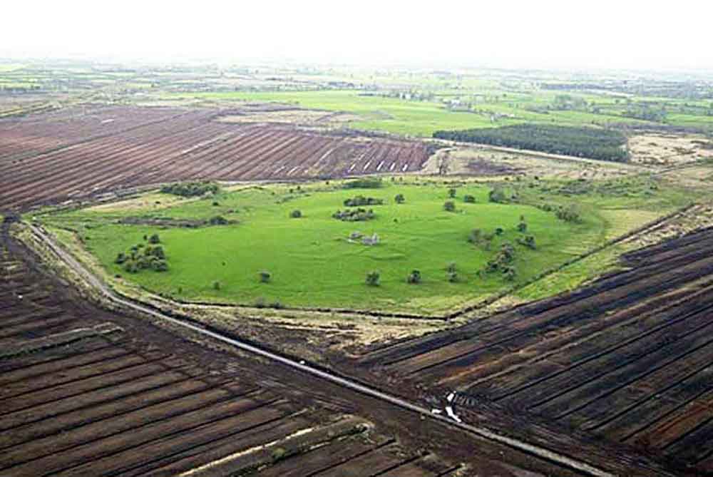
Okasha/Forsyth/2001, 196–197: `Derrynaflan is a virtual island, c. 30 hectares in extent, in the extensive bog of Littleton. It is mentioned as Daire na Fland, `oak-grove of the Flanns’, and under its earlier name Daire Eidnech, `ivied oak-grove’, in several hagiographical sources .. Situated on the border of Éile and Éogonacht … Derrynaflan appears to have flourished between the early eighth century and the early-to-mid ninth century when it was one of the most important centres of the céli Dé reform movement … After the death in 847 of its patron Feidlimid mac Crimthainn, King-Bishop of Cashel, the monastery appears to have declined although there are ruins of ecclesiastical buildings of possibly thirteenth-century date … The famous hoard of ecclesiastical silver was discovered in 1980 as a result of unlicensed digging. It was concealed near the pre-Romanesque church within the monastic enclosure and had probably been buried there in the later ninth or tenth century. The objects were made at different periods through the eighth and early ninth centuries, that is, during the site’s hey-day … The standing remains at Derrynaflan include a pre-Norman single-celled church without antae … and to the north-east a trapezoidal enclosure, open on one side. The presence of some carved medieval slabs indicate that this was a graveyard’.
Corcanadan of Derrynaflan (Doire Eidhneach,later Doire na Bhflann) A person of this name is included in the list of Saints of the Dál Meisin Corb of Co. Wicklow, which describes him as one of two brothers of Caomhán of Anatrim, the other being Muirdheacbhair (Lgen 726). All three are brought together in two other lists of holy persons – those commemorated on the 3rd. Nov and those associated, according to an early litany, with Caoimhghin of Glendalough. The latter text locates Corcanadan at Derrynaflan. It has been suggested that the saints name may have originated as a gentilic i.e. Corca Nodain (Nudáin).
 Derrynaflan Hoard (from Database of Irish Excavation Reports)
The 1986 season concentrated on the area surrounding the hoard findspot (Area 1 in 1985 report) and involved the re-excavation of a trench partially explored in 1980 (see M. Ryan (ed.), The Derrynaflan Hoard 1. A Preliminary Account, Dublin 1983, 52-3). Re-excavation of the hoard pit indicated that it had been partially dug in the W edge of an oval pit, 3m x 2m, which contained sterile boulder clay. It is thus not possible to establish a terminus post quem for the deposition of the hoard.
A further stretch of the linear ditch contained imported Bii ware. It is the earliest feature on the site and its orientation is at variance with the other ditches and buildings. Excavation in the 1986 season indicated that the field bank overlay a ditch running N-S outside the E gable of the church. The V-shaped ditch contained charcoal and animal bone, a number of bronze and iron stick pins, bone comb fragments, cut antler and a piece of sheet bronze decorated with an engraved Ringerike-style foliage pattern.
A large pit, 1.80m deep and dug into boulder clay, was back-filled with a mixture of clay and mortar. The back-till also contained a sherd of medieval pottery and the pit may be associated with one of the building phases on the site.
Raghnall O Floinn, National Museum of Ireland, Dublin
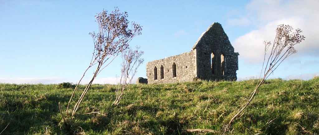 A view of the Church ruin on Derrynaflann Island.
Derrynaflan Island, also known as Goban Saor’s island, is situated in the middle of Littleton bog. The name derives from the Oak Wood of the Two Flanns, a reference to two prominent century clerics who lived during the 800s, both of whom were associated with the place. It has a history as an ecclesiastical settlement from early Christian times to the 1700s.
The foundation of the first monastic settlement is attributed to St. Ruadhan of Lorrha in the 500s AD. Derrynaflan was at its height between 700 and 900 AD when it was associated with the Celi Dé movement in the early Irish Church. The term Celi Dé or Culdees means ‘companions of God’. These were hermetic communities who sought out isolated locations such as Derrynaflan and lived in austere fashion. The monastic settlement appears to have gone into decline in the late 800s, possibly due to the Viking invasions and the demise of the Eoganacht dynasty of Cashel. The ruined church on the island dates from two distinct periods. The first phase is a pre- Norman single cell church. The chancel was added during the 1200s and incorporated the earlier church as a nave. One wall of a walled enclosure remains standing close to the church.
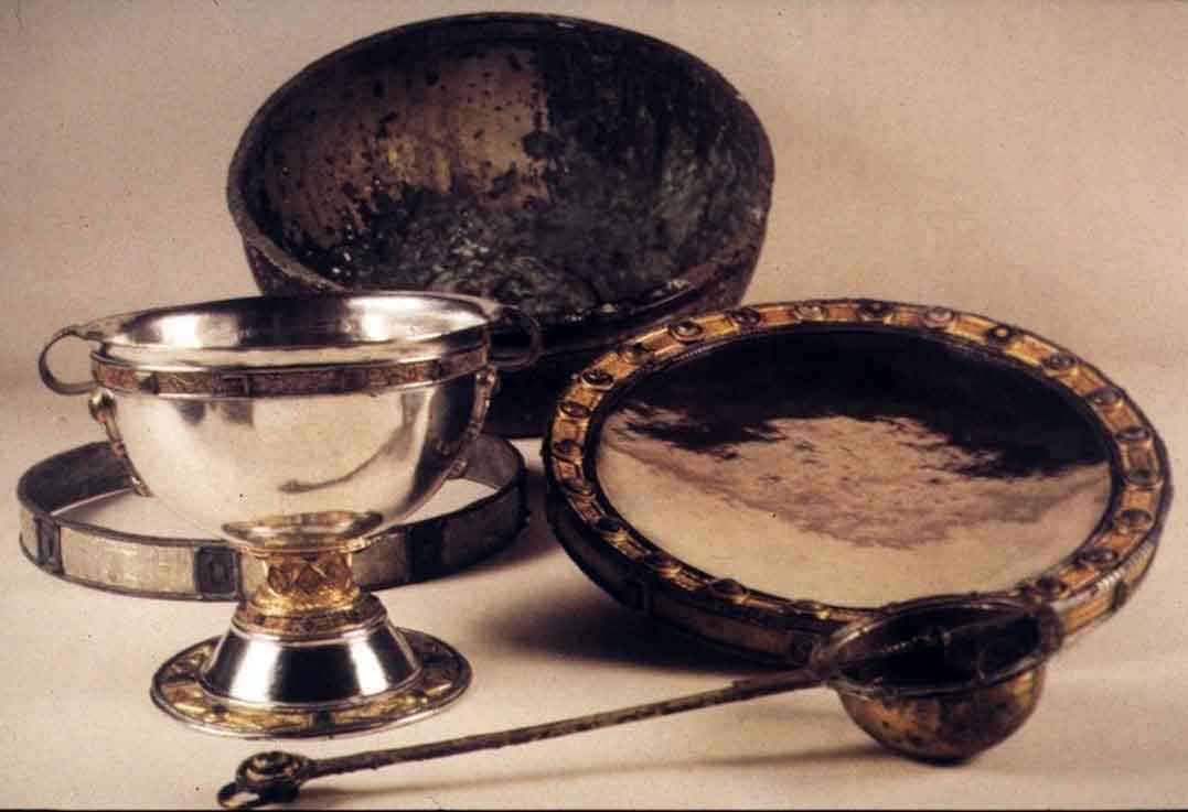
A small Franciscan community continued largely unnoticed on the island between 1676 and 1717. This was during a period of suppression of the Catholic Church in Ireland following the Cromwellian conquest, the Williamite Wars and the enforcement of the Penal Laws. Derrynaflan came to international prominence following the discovery there in February 1980 of the Derrynaflan hoard. The hoard consists of five liturgical vessels: a silver chalice, which is decorated with gold filigree and amber ornaments, a silver paten, a bronze strainer, a silver hoop and a bronze basin. It is thought that the hoard was concealed in the early 900s. The objects were restored by the British Museum and are now on public display in the National Museum of Ireland, Kildare Street, Dublin. The hoard is considered a prime example of the Insular Celtic style of metalwork from this period in our history. The hoard was discovered by Michael Webb of Clonmel and his son by using a metal detector. It was then passed on to the Director of them National Museum. A complex and lengthy legal battle ensued over the ownership of the hoard and the case was ultimately decided in the Supreme Court in 1987.
The court ruled that ownership of the hoard resided in the State. The case received widespread publicity at the time and had significant implications for official policy and legislation on national monuments and archaeology. It led to new legislation on excavations and a ban on metal detecting for archaeological objects. Derrynaflan is reputed to be the burial place of An Gobán Saor (Goban the builder), a famed architect, stonemason and builder of churches in Ireland in the decades around 600 AD. He is said to have been born near Malahide, Co. Dublin in 560 AD. He is alluded to in an Irish poem from the 700s, is mentioned in the Life of St. Abban and also has an entry in the Catholic Encyclopaedia. A wealth of folklore abounds concerning the life of An Gobán. Three graveslabs on the eastern side of the island are said to mark the burial place of the Goban and his family. In recent years, dawn mass on Easter Sunday morning on Derrynaflan Island has become an annual event. Direct vehicular access to Derrynaflan is difficult but it can be accessed on foot from Liskeveen townland in the north or from Lurgoe in the south
The Goban Saor’, or the Artificer (fl. 7th century), a prominent figure in Irish tradition, is said by Petrie in his ‘Essay on the Round Towers of Ireland,’ upon the authority of the Dinnsenchus preserved in the books of Lecan and Ballymote, to have been the son of a skilful artisan in wood named Tuirbi, from whom Turvey in the barony of Nethercross, Co. Dublin, is named, and to have flourished (according to O’Flaherty’s chronology) A.M. 2764. But O’Curry has shown that this is an error due to a mistranslation furnished to Dr. Petrie. O’Curry is probably right in saying ‘there is little doubt that Gobban was a descendant of Tadg, son of Cian, son of Olioll Olum, who settled in Meath in the third century.’
Gobban is first mentioned in an Irish poem attributed to a lunatic protected by St. Molling, preserved in a manuscript belonging to the monastery of St. Paul in Carinthia, and assigned by Herr Mone to the eighth century. It speaks of a fort made by Gobban in Tuaim Inbir (West Meath). In the life of St. Aedh or Maedhog of Ferns (d. 632) Gobban is said to have been employed by the saint in building a church (basilica, said by Petrie to imply a stone building), and Aedh’s successor, Mochua of Luachair (d. 652), is said to have employed him upon a wooden church.
But the saint whose life contains most information about Gobban is St. Daircell or Molling [q. v.], who lived to the age of eighty-four, and died 690. After the fall of a famous yew tree named the Eo Rossa, celebrated in a poem in the ‘Book of Leinster’ as ‘noblest of trees, the glory of Leinster,’ some of the wood was presented to Gobban by St. Molaisse, and Gobban was engaged to make an oratory out of it.
The first chip which Gobban cut struck Daircell in the eye, and a passage in the Brehon laws implies that the injury was intentional. Gobban’s wife urged him to demand as payment for the work as much rye as the oratory would contain. Daircell assented; but being unable to get rye enough filled it instead with nuts and apples, which he made to appear like rye, but which changed to worms when Gobban took them home. There is also a mention of his having constructed a building for St. Abban, who died in the seventh century. Gobban is said to have been blind at the time, and to have received a temporary gift of his sight from Abban until the completion of the work. The ecclesiastics who employed Gobban complained that his charges were too high, and it was generally believed that his blindness was a visitation due to their anger.
Among the buildings traditionally ascribed to him are the tower of Antrim, the tower and church of Kilmacduagh, and, according to Dr. Petrie, the tower and church of Glendalough. His work was confined chiefly to the north and east of Ireland, and there is no tradition that he ever visited or was employed south-west of Galway or Tipperary. In the north-east of Antrim in the parish of Ramoan is a building described on the ordnance map as ‘Gobbin’s Heir’s Castle.’ The first two words, as Bishop Reeves observes, are evidently a corruption of Gobban Saer, but the term castle is a complete perversion. The cave near, also connected with him, has a large cross carved on the roof stones over the entrance of the ante-chamber. It is a Latin cross, formed by double incised lines carved on a sandstone slab—very regular, and extremely well executed. There is also a smaller cross with equal arms.
The traditions respecting him all refer to the seventh century, when he must have lived. He employed workmen, and erected duns or fortresses, churches, oratories, and towers, the existing buildings attributed to him giving evidence of his skill. According to the tradition of the neighbourhood he was buried at Derrynaflan, parish of Graystown, barony of Slieveardagh, county of Tipperary.
___________________________________________________________________
The Settlement and Architecture of Later Medieval, Slieveardagh, County Tipperary.
Richard Clutterbuck – Volume II
This thesis is presented in fulfilment of the regulations for the degree of M.Utt, in Archaeology, University College Dublin.
Supervisors:, Prof. Barry Raftery, Dr. Tadhg O’Keeffe, Dr. Muiris 0’Sullivan, Date: August 1998.
Description: Derrynaflan church consists of at least two phases of construction most obviously made up of the remains of an early medieval (pre-Norman) church and an additional thirteenth century chancel incorporating the earlier chapel as a nave. A buttressed wall stands to the north-west of the nave and chancel and app))ars to have been part of an enclosure delimited on the other sides by an earth-work (see a Floinn 198~, 50-51) (Fig. 12). The pre-Norman portion of Derrynaflan church measures 12.8 metres (0 Floinn 1983, 50) and is constructed of large dressed limestone blocks facing a rouble core and only survives to a few courses height on the south wall. The north and most of the west wall have been totally destroyed. An anta survives on the south-west corner of the church (contrary to a Floinn 1983,50,51) and also as a staggered portion of the south wall of the church where the thirteenth century chancel was built against the inner face of the original south-eastern ant~. The chancel was added at a later stage. The chancel measures 6.5 metres by 9.9 metres (0 Floinn 1983, 50) and is constructed of uncoursed roughly dressed limestone with dressed limestone quoins. The proj~cting eaves on the east gable have an overlapping tile effect carved on their upper sides (0 Floinn 1983,50). The chancel interior was lit by two trefoil headed lancet lights on the east wall with an internal splay and segmented back arches (Plate 18). Three similar windows are found on the south wall and the bottom half of another can be found on the north wall. A recesses in the eastern end of the south wall is executed in dressed sandstone with a semi-circular head with a surrounding pellet ornament. This appears to be the ~emains of a Romanesque window possible reused from the original pre-Norman church (0 Floinn 1983,50). A door made in red sandstone apparently similar to Cormac’s chapel (the Rock of Cashel) was said to exist at Derrynaflan in the last century (O.S. Name Books 129, 498-526).
Location Derrynaflan is situated as an island in the middle of the Littleton bog in the west of the study area (Fig. 32). The island is 3.9km north-west of Graystown (28) and 4.5km north-east of Ballinnre (7). Derrynaflan church is sited at an altitude of 139 metres on the highest point in the island. The site is relatively inaccessible and is now reached along the nineteenth century line of a railway track.
History Derrynaflan island was the site of an early medieval ecclesiastical establishment which had its height in the eight and ninth senturies, corresponding with the Celi De ascetic movement in the early Irish church (0 Muraile 1983, 58). This early medieval tradition produced the Derrynaflan hoard found at the site in 1980 (Ricardson 1980; Ryan 1983). Derrynaflan continued as a religious site during the Anglo-Norman period. a Floinn speculated that Derrynaflan may have been the site of an Augustinian community established in the vicinity of Killenaule as a condition of the granting of lands to the Cannons of Christ Church, Dublin in 1220 (6 Floinn 1983, 51). Derrynaflan is recorded as a pr~bend of Cashel in 1302-07, where it was valued at 4 marks (Cal. Doc. Ire. 1302-07, 285; a Muraile 1983, 59). The church of Dereneflyn is mentioned in a list of Procurations of the Abbot of Cashel and Ernly in 1437, however, the amount taxed does not survive (Seymour 1908, 331). Derrynaflan does not appear again until 1615 when the Royal Visitation recorded the state of the church in the Diocese. The church of Derrynaflan ‘fas impropriate, however, it was also in ruins with no service (Murphy 1912, 291; a Muraile 1»83, 59). In 1635 Derrynaflan was the property of Jacubus Laffan of Graystown (0 Muraile 1983, 59). The Down Survey depicts the ruined church of Derrynaflan on an island in the bog of Ely. Derrynaflan appears in the historical record between 1676 and 1717 as home to a Franciscan community, presumably taking advantage of the sites isolation in a period when the Catholic church in Ireland was under severe pressure from the penal laws (0 Muraile 1983,59).

View of the church at Derrynaflan with Killeens bog in the background.
Derrynaflan Church, – Lurgoe Td., Graystown PI., – 54/1, – S 182495, – T1054-00202, – 1111997The north west of the chancel measures 13.8 metres and survives to a height of 4.10 metres. The wall has three buttresses and a base batter on its west face. The wall also has two rough breaches which appear to be secondary windows. This wall appears to be one side of an enclosure adjacent to the north side of the church. The rest of the enclosure is represented by an earthen bank and would have original formed an area of 12.50 metres square (0 F10inn 1983, 50). A bullaun stone and a finial stone are placed in the interior of the chancel and this is closed off from cattle by a wooden fence. The earthworks around the site cover the entire island and date from the initial early medieval settlement up to nineteenth century. Two medieval grave slabs are situated to the south-east of the church.These are surrounded by a wooden fence and are traditionally associated with the grave of a character called the Goban Saar (Kelly 1983,46; Maher 1997, 54).
Comment: The church of Derrynaflan consists of two phases: a pre-Norman chapel andthirteenth century nave and chancel. The pre-Norman chapel has diagnostic similarities with other churches such as the ante and the massive limestone ashlar facing rubble core. The Romanesque fragments incorporated into the later chancel and the door described from the last century suggest a twelfth century date. The chancel can be dated to the thirteenth century by the trefoil-headed windows. The detached north-western wall is dated by O Fl0inn to the fifteenth century. He speculates that the enclosure created to the north of the church is similar in size to the small cloister associated with a minor Augustinian house like Inis Cleraun and may represent the Augustinian community apparently obliged to established themselves in the vicinity of Killenaule as part of the grant of lands to the Cannons of Christ Church in 1220 (0 Floinn 1983, 51). However, Derrynaflan is an extremely isolated location surrounded by marginal and dangerous land which is far removed from the centres of population favoured by the Augustinians. The enclosure or building may be the remains of a residence similar to a hall house. The church obviously brought in enough income to support a prebendary in the early fourteenth century as well as justify a substantial medieval church. This may be a retention of the status from the pre,Norman church represented by the chalice, paten and strainer found at the site in 1980 (0 Rford:iin. 1983, 1-2; Ryan 1983, 3-16). The Franciscan occupation of the site in the later seventeenth and early eighteenth centuries appears to have left no impression on the fabric of the church, although they must have used it for worship.
Derrynaflan church consists of at least two phases of construction most obviously made up of the remains of an early medieval (pre-Norman) church and an additional thirteenth century chancel incorporating the earlier chapel as a nave. A buttressed wall stands to the north-west of the nave and chancel and app))ars to have been part of an enclosure delimited on the other sides by an earth-work (see a Floinn 198~, 50-51) (Fig. 12). The pre-Norman portion of Derrynaflan church measures 12.8 metres (0 Floinn 1983, 50) and is constructed of large dressed limestone blocks facing a rouble core and only survives to a few courses height on the south wall. The north and most of the west wall have been totally destroyed. An anta survives on the south-west corner of the church (contrary to a Floinn 1983,50,51) and also as a staggered portion of the south wall of the church where the thirteenth century chancel was built against the inner face of the original south-eastern anta. The chancel was added at a later stage. The chancel measures 6.5 metres by 9.9 metres (0 Floinn 1983, 50) and is constructed of uncoursed roughly dressed limestone with dressed limestone quoins. The proj~cting eaves on the east gable have an overlapping tile effect carved on their upper sides (0 Floinn 1983,50). The chancel interior was lit by two trefoil headed lancet lights on the east wall with an internal splay and segmented back arches (Plate 18). Three similar windows are found on the south wall and the bottom half of another can be found on the north wall. A recesses in the eastern end of the south wall is executed in dressed sandstone with a semi-circular head with a surrounding pellet ornament. This appears to be the ~emains of a Romanesque window possible reused from the original pre-Norman church (0 Floinn 1983,50). A door made in red sandstone apparently similar to Cormac’s chapel (the Rock of Cashel) was said to exist at Derrynaflan in the last century (O.S. Name Books 129, 498-526). The detached wall to
Location: Derrynaflan is situated as an island in the middle of the Littleton bog in the west of the study area (Fig. 32). The island is 3.9km north-west of Graystown (28) and 4.5km north-east of Ballinnre (7). Derrynaflan church is sited at an altitude of 139 metres on the highest point in the island. The site is relatively inaccessible and is now reached along the nineteenth century line of a railway track.
History: Derrynaflan island was the site of an early medieval ecclesiastical establishment which had its height in the eight and ninth senturies, corresponding with the Celi De ascetic movement in the early Irish church (0 Muraile 1983, 58). This early medieval tradition produced the Derrynaflan hoard found at the site in 1980 (Ricardson 1980; Ryan 1983). Derrynaflan continued as a religious site during the Anglo-Norman period. a Floinn speculated that Derrynaflan may have been the site of an Augustinian community established in the vicinity of Killenaule as a condition of the granting of lands to the Cannons of Christ Church, Dublin in 1220 (O Floinn 1983, 51). Derrynaflan is recorded as a prebend of Cashel in 1302-07, where it was valued at 4 marks (Cal. Doc. Ire. 1302-07, 285; a Muraile 1983, 59). The church of Dereneflyn is mentioned in a list of Procurations of the Abbot of Cashel and Ernly in 1437, however, the amount taxed does not survive (Seymour 1908, 331). Derrynaflan does not appear again until 1615 when the Royal Visitation recorded the state of the church in the Diocese. The church of Derrynaflan ‘fas impropriate, however, it was also in ruins with no service (Murphy 1912, 291; a Muraile 1»83, 59). In 1635 Derrynaflan was the property of Jacubus Laffan of Graystown (0 Muraile 1983, 59). The Down Survey depicts the ruined church of Derrynaflan on an island in the bog of Ely. Derrynaflan appears in the historical record between 1676 and 1717 as home to a Franciscan community, presumably taking advantage of the sites isolation in a peri9d when the Catholic church in Ireland was under severe pressure from the penal laws (0 Muraile 1983,59).
Derrynaflan Church, – Lurgoe Td., Graystown PI., – 54/1, – S 182495, – T1054-00202, – 1111997. The north west of the chancel measures 13.8 metres and survives to a height of 4.10 metres. The wall has three buttresses and a base batter on its west face. The wall also has two rough breaches which appear to be secondary windows. This wall appears to be one side of an enclosure adjacent to the north side of the church. The rest of the enclosure is represented by an earthen bank and would have original formed an area of 12.50 metres square (0 Fl0inn 1983, 50). A bullaun stone and a finial stone are placed in the interior of the chancel and this is closed off from cattle by a wooden fence. The earthworks around the site cover the entire island and date from the initial early medieval settlement up to nineteenth century. Two medieval grave slabs are situated to the south-east of the church. These are surrounded by a wooden fence and are traditionally associated with the grave of a character called the Goban Saar (Kelly 1983,46; Maher 1997, 54).
Comment: The church of Derrynaflan consists of two phases: a pre-Norman chapel and thirteenth century nave and chancel. The pre-Norman chapel has diagnostic similarities with other churches such as the ante and the massive limestone ashlar facing rubble core. The Romanesque fragments incorporated into the later chancel and the door described from the last century suggest a twelfth century date. The chancel can be dated to the thirteenth century by the trefoil-headed windows. The detached north-western wall is dated by O Fl0inn to the fifteenth century. He speculates that the enclosure created to the north of the church is similar in size to the small cloister associated with a minor Augustinian house like Inis Cleraun and may represent the Augustinian community apparently obliged to established themselves in the vicinity pf Killenaule as part of the grant of lands to the Cannons of Christ Church in 1220 (O’Floinn 1983, 51). However, Derrynaflan is an extremely isolated location surrounded by marginal and dangerous land which is far removed from the centres of population favoured by the Augustinians. The enclosure or building may be the remains of a residence similar to a hall house. The church obviously brought in enough income to support a prebendary in the early fomteenth century as well as justify a substantial medieval church. This may be a retention of the status from the pre,Norman church represented by the chalice, paten and strainer found at the site in 1980. The Franciscan occupation of the site in the later seventeenth and early eighteenth centuries appears to have left no impression on the fabric of the church, although they must have used it for worship.