Buolick
Buolick
The Medieval Parish of Buolick
The medieval parish of Buolick was bounded on the north by Fennor parish, on the east by Ballingarry parish and on the west by a detached part of the parishes of Kilcooley and Fennor. The religious centre of the parish was the Buolick settlement, where the church dates from the late 15th century. Buolick is mentioned in the papal taxation records of 1281 and 1302. In 1291, the value of the clerical ‘livings’ or revenue, was estimated at 13 marks and in 1301 at 12 marks. In the year 1200 one Mannaseur Arsic held the manor of Buolick. Later, in the year 1307 one John Assyk lord of the manor granted the revenues of the church with fifteen acres of land to the priory of the Hospital of St. John of Dublin. The priory in turn provided a priest to officiate in the parish. By 1445, at the suppression of the monasteries, the priory was still in possession of the revenues of Buolick. When the lands of Buolick left the possession of John Assyk they came into the hands of the Butler family.
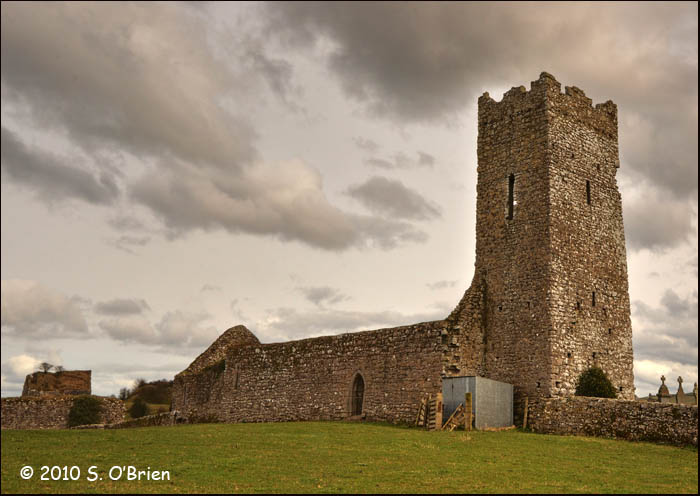
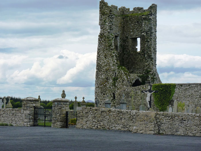
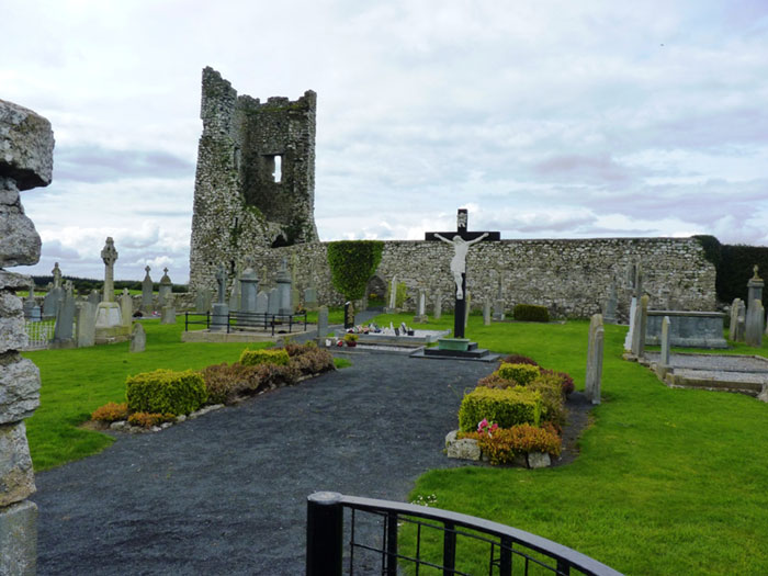
In the early 1600s many religious centres through out the country were burned down and it was during this period that Buolick was attacked and destroyed. Between the years of 1600 and 1750 very little is known of the actual history of the church but it was again used as a parish church in 1752. In July 1754 Dr. Edmond Butler visited Buolick and in his report we see that the church was dedicated to the Assumption of the Blessed Virgin. He also stated that “the chalice being used belonged to the Fransiscans of Thurles. There was one old corporal, one good alter stone, one old alb, one amict, one cincture, two good alter tombs, a plate pixis plate, oylstock and old vestment with its maniple and stole vellum which all belonged to the parish”. The last recorded visit of Dr. Edmond Butler was on July 13th 1758. On this visit the parishes death, birth and marriage rolls were recorded, so also were the name of the ‘public sinners’. The church seems to have fallen into disuse at this time. The church is a large building with a large four storey tower at the Western end. The ground floor of the tower is vaulted there are several post holes probably used for the erection of an additional building.
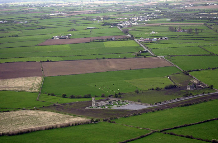
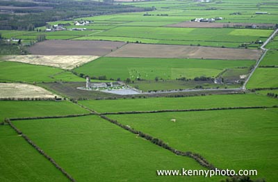
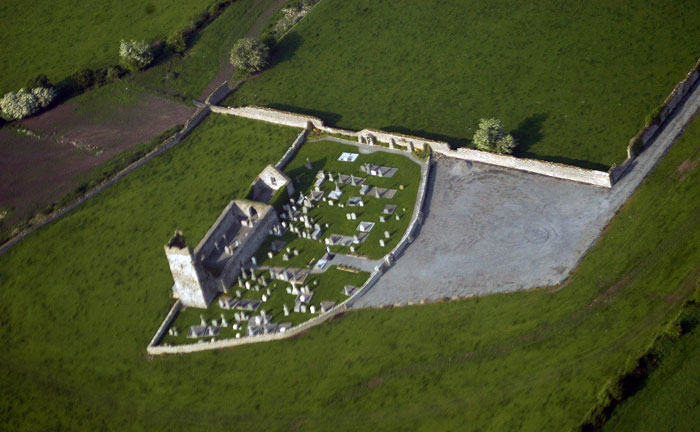 An aerial view of Buolick Graveyard and Church photo courtesy of Joe Kenny , photography, Fethard
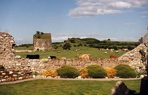
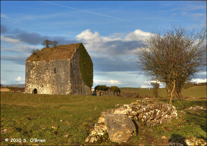
A short distance from the church there is the large Bawnreigh castle; built in the late 15th or early 16th century. In 1640 the civil survey records it as; “a good castle and some cabins wanting repair”, stood at Buolick. The owner of Buolick at this time was James Butler, Earl of Ormond. The Butlers did not always live at Buolick and sometimes the tower house was leased to other noble families including other septs of the greater Butler clan. For instance, in 1578 Pierce Butler leased the castle from Thomas Earl of Ormond and was bound to keep the manor in as “good a manner” as Richard Cooke did. The lease was for twenty one years at an annual rent of £32. Another non Butler rentee was one Milo Cantwell in the year 1307. Two owners previous to this were John Adam circa 1259 and William Laffeyn circa 1290. The manor was inhabited during the 18th century by Mr. William Barker when he was forced to stay there due to lack of accommodation at Kilcooley. Mark Byrne also held some of the estate around the 1850’s.
Within a mile of each other at the settlement of Buolick there are a pair of Moates and Baileys. There is also evidence of open-field farming which can still be seen in the very large bawn and paddock. From this evidence it can be assumed that Buolick was occupied by Anglo-Normans. The ‘Down Survey’ map shows that six acres of land in Buolick were divided into eighteen strip plots. In 1890 two large bronze bells were discovered in Boulick while a grave was being dug. The bells were discovered under the partly ruined tower of the church. The finder gave them to the then Archbishop Croke who left them in the garden of his palace at Thurles. The great antiquity of these two bells was not until 1972, and it is prpable that they at one time hung in Kilcooly Abbey. In September 1973 both bells were installed in Holycross Abbey and re-dedicated to St. Michael and St. Gabriel.
Buolick in History
Buolick rests in the barony of Slieveardagh, bounded on the north by Fennor, east by Ballingarry, and on the west by the detached part of Kilcooley and Fennor. The remains of the motte and Baile, the castle and the church are in evidence today and clearly point to the importance of this medieval parish in yesteryear.
In the year 1200 Mannaseur Arsic held the manor at Buolick and later, in the year 1307, John Assky, Lord of the manor, granted the revenues of the church with fifteen acres of land to the priory of the hospital of St. John of Dublin. The Priory then provided a priest to officiate in the parish.
In the early 14th century the lands and castle in Buolick changed ownership from Assky to the Butlers. In the early 1600’s, many religious centres in the country were burned down and unfortunately Buolick was not spared this fate. It was both attacked and destroyed. Between the years 1600 and 1750 very little is known of the actual history of the church, but in 1752 it was again used as a parish church. In July 1754 Dr. Edmond Butler, Archbishop of Cashel, visited Buolick and in his report we see that the church is dedicated to the Assumption of the Blessed Virgin. He also stated; ‘The chalice being used belonged to the Franciscans of Thurles’. The last recorded visit of Dr. Edmond Butler was on July 13th 1758. On this visit the death, birth and marriage statistics were recorded and so also were the names of the public sinners. The church seems to have fallen into disuse at this time.
A short distance from the church is a large castle, known as Bawnreigh Castle. It was built in the late 15th or early 16th century. In 1640 the Civil Survey records that ‘a good castle with some cabins wanting repair’ stood at Buolick. The owner of Buolick at this time was James Butler, Earl of Ormond. However, the Butlers did not always live at Buolick, the tower house was sometimes leased. In 1578 Pierce Butler leased the castle from Thomas, Earl of Ormond, and was bound to keep th~ castle in as ‘good a manner’ as Richard Cooke did. The lease was for 21 years at the annual rent of thirty -two pounds. It is worth mentioning that the afore-named castle was prece~d by an earlier manor or castle. That castle was leased to John Adam in 1259 and to William Laffeyn in 1290. Milo Cantwellleased it in 1307. During the 18th century Mr. William Barker inhabited the manor owing to a lack of accommodation in Kilcooley. Mark Byrne also held some of the estate around the 1850’s.
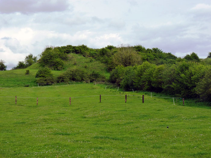
The Motte and Bailie at Buolick date from the Norman times in the early 13th century. There is also evidence of open-field farming which can still be seen in the very large bawn and paddock.
In the year 1890 Buolick once again came to prominence when two large bells were discovered when the grave of a Lanigan was being dug. The bells were buried under the partly ruined tower of the church. They were given to Dr. Croke, then Archbishop of Cashel and were kept in the garden of his house in Thurles. In September 1973 both bells were hung in Holycross Abbey and were re- dedicated by Dr. Morris to St. Michael and St. Gabriel. Some believe the Boulick bells were originally housed in nearly Kilcooly Abbey.
Gortnahoe came to be the centre of population and the present church in Gortnahoe was built there in 1820. However Buolick remained a very sacred and venerated spot and is used as a cemetery by many families of the parish and surrounding parishes up to the present day. The renovation and clean-up of the site has brought a new sense of pride and interest in the church, the cemetery and in all the families buried there.
“Death is God’s great equaliser, For the monarch and the slave;
And the millionaire and beggar, All are equal in the grave.”
The Settlement and Architecture of Later Medieval, Slieveardagh, County Tipperary.
Richard Clutterbuck – Volume II
This thesis is presented in fulfilment of the regulations for the degree of M.Utt, in Archaeology, University College Dublin.
Head of Department: Supervisors:Prof. Barry Raftery, Dr. Tadhg O’Keeffe, Dr. Muiris 0’Sullivan. – August 1998
Buolick Tower House, Buolick Td., Buolick Pr, 48/7, S 262 563, Tl048-020, 1/998
Location: Buolick is situated in north central Slieveardagh, on the northern lowlands (Fig. 26). The land is used today for both grazing and tillage. The majority of the profitable land use was arable in 1654 (Civil Survey I, 128).
Buolick townland straddled the northern lowlands from the hills to the bogs. Buolick is 3.3km south west of Kilcooly Abbey and 2km west of Clonarnicklon castle.
Buolick castle was sited at an altitude of between 130 metres and 140 metres on level ground 442 metres to the north west of a small stream. The site is exposed with excellent view in all directions. The castle can be reached along a modern gravel path from the main road in the north east which runs past the castle to the nearby grave yard of Buolick church (10) (Fig. 41). Paths ran next to the site which have ceased to function and which may date from the medieval period.
Historical: Buolick is recorded as a borough in 1359, 1372 and 1389 (Martin 1979, 36). Edmund Butler, who adopted the name MacRichard, built the castle at Buolick in 1453 (Butler 1963-4, 220; Cairns, 1987, 35).The Earl of Ormond was in possession of the townland in 1641 when the castle was still in good repair (Civil Survey I, 101, 128). The Down Survey depicts the castle with a church to the west and three houses to the north (Fig. 28). Catherine Butler, who was presumably resident in the tower house was returned with a single hearth for each year of the Hearth tax in 1665 and 1666/7 (Laffan 1911, 35, 135). Buolick castle was lived in until the eighteenth century when William Barker of Kilcooly visited it (Neely 1983, 135)
Description: Buolick towerhouse is three storey structure constructed of roughly coursed well dressed limestone with a stone vaulted roof and external measurements of 9.2 metres by 11.35 metres (excluding the base batter) (Fig. 38, Plate 10). The building has a prominent base batter and large limestone quoins. The castle has an internal vault over the ground floor and another forming the roof. The upper floors are reached by a mural stair in the west and south walls.
Buolick tower house is entered through a pointed arch door frame in the west wall. The entrance had a yett held in place by chains through the holes in the right jamb and apex of the door frame. The door was also secured by a cross bar fitted in a deep aperture inside the entrance left jamb. Immediately inside the entrance is a lobby. The ground floor chamber and stairs were secured behind inward opening pointed doors with cross bars. The lobby also has a wide murderhole in the ceiling from the first floor.
The ground floor is a dark chamber with a bluntly pointed stone vaulted ceiling. The impression of the wicker centring still adheres to one side of the vault. The chamber is lit by three narrow slit windows set in deep embrasures in the north-east and south walls. The windows have loops on the jambs to facilitate a wide field of fire for archery and later for guns. Two wall cupboards are set low at either end of the east wall.
The first floor main chamber is entered off a short landing. The landing and mural stairs are lit two slit windows. The window opposite the first floor entrance has a slop stone beneath it.
The first floor main chamber was lit by three windows and had a fire place and a garderobe. The chamber was entered was through a pointed arch door frame with original hanging eye and pivot holes for the door still in place. The south ogee-headed window is set in an embrasure beneath the mural stairs. The square headed west window is set in an embrasure beside the fire place. The wide east window embrasure has been broken out.
The fire place has been destroyed, exposing the chimney flue. The murder hole was recessed into the wall beside the fireplace and appears to have been covered when not in use to create additional cupboard space. The gaderobe is at the end of a passage in the north wall. The passage is lit by three small slit windows and consisted of an flag stone forming the seat beside a chute to the exterior ground level. This probably had a wooden seat when in use.
The second floor was entered directly off the stairs from the first floor landing through a square headed door. The single chamber had a wooden floor and a low, stone vaulted ceiling which sprung from floor level. the wooden floor has been removed. This sparse room was lit by a single deeply splayed window in the north wall. A rough shallow recesses in the east wall may have accommodated furniture such as a bed.
The stairs emerged at parapet level with a slight inturning of the wall at the exit which originally had a door. The roof is a stone vault rising to a gable and over grown with grass and some thorn bushes. Nothing remains of the original parapet or the chimney. Theparapet walk allowed access to the west north and east sides of the tower. Nothing remains of the original crenellations except on the north side where the parapet walk passed between the crenellations and the gable of the roof.
The west facade of the tower has the impression of a gable of roof chased in the stone. Earthworks to the west of the site also appears to the remains of an attached hall. This addition would have obscured the original tower entrance and blocked the lower mural stairs window. The tower houses is sited within a large stone enclosure (Fig. 40). The walls are later than the tower house, probably built in the seventeenth or eighteenth century. If the tower house original had a bawn wall, it may survive as part of the earthworks surrounding the tower house.
Comment: Buolick tower house is most striking for its stone vaulted roof. The tower is also short at only three storeys high. It is strongly built and has suffered relatively little decay. The hole in the first floor east embrasure was probably a result of the salvaging of the interior oak floors. This mid-fifteenth century tower house is one of the earliest examples in the study area. The arrow loops on the ground floor and the ogee head light are typical fifteenth century features. The ground floor was probably used for storage with the first floor as the main hall and the second was private chambers. Buolick castle was built on land which was recorded as a rural borough (Martin, G. 1979, 36) and may have occupied one of these burgage plots.
Buolick Church
Boulick Td., Buolick Pr. 48/4, S 258 564, TI048-020, 1/1998
Location: Buolick is situated in the northern lowlands on fertile slightly undulating ground. Buolick is 3.3km south west of Kilcooly and 2km west of Clonamicklon (Fig. 37). The church is situated 175 metres west of Buolick tower house (Fig. 40, 41). Buolick Church is sited at an altitude of approximately 135 metres on a slight rise above a small stream. the church grave yard is still in use and has had a modern path laid to it from the main road 600 metres to the north-east.
History: In 1200 the tithes of the tuath called Gortcorke, corresponding with the parish of Buolick, were granted by Mannasserus Arsic to the Hospital of St. John the Baptist, Dublin (Hennessy 1985, 63). In 1259 John Adam, a burgess of Buolick granted half a croft to the Hospital of St. John (Bradley 1985, 57; Reg. St John Baptist, Dublin, 319).
Buolick Rectory was valued at 13 marks in the ecclesiastical taxation of 1302-07 (Cal. Doc. Ire. 1302-07, 285). Buolick is taxed for 40 shillings in the list of Procurations of the Abbot of Cashel and Emly in 1437 (Seymour 1908, 331). In 1422 the Hospital of St. John the Baptist lands at Buolick are mentioned in a grant (Orm. Deeds II, 42) Donald Imachvir held the vicarage of Buolick in 1506 and in 1507 Thomas Bryth who was not recognised as a priest detained the vicarage (Cal. Papal Regis. XVIII, 528). In 1540-41, when the Hospital of St. John the Baptist was dissolved, it held I messuage and 10 acres of arable land worth 7 shillings 8 pence at Buolick. In 1607 the vicarage of Buolick was returned as void and destitute of an incumbent (Cal. State Papers Ire. 1606-08, 24 I).
Nicholas Netterville held the vicarage in 1615 though the church did not have a service and was in ruins (Murphy 1912, 290). In 1640 Buolick church had six acres of arable glebe land scattered around the townland in parcels described as dispersed upp & downe in several ridges, whereby it could not be bounded (Civil SurveyII, 401). The Down survey depicts nineteen parcels of Glebe land scattered around the townland, most of which consisted of long strips.
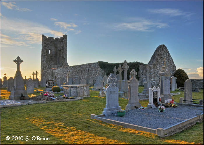
Description: Buolick church is the largest medieval church in the study area with the exception of the church in the abbey at Kilcooly. Buolick church consists of a large nave with a residential tower on the west end and an additional chancel built in a later phase on the east end of the church (Fig. 39, Plate II). The nave measures 23.55 metres by 9.9 metres, the residential tower 4.4 metres by 4.6 metres and the chancel 9.7 metres by 7.95 metres (all externally excluding base batters). The church nave has a length to width ratio of 2.4: I. The church appears to have been burnt down at some stage as the stone work shows extensive fire cracking and heat damage and the eastern side of the residential tower has collapsed. However, this may also have been caused by modern burning of ivy on the walls.
Buolick church has a grave yard on its southern side contained in a curving wall attached to the churches residential tower and the secondary bawn wall of Buolick tower house. The original enclosure was circular and remains as a crescent earth work on the north side of the present grave yard, visible in aerial photographs (St. Joseph 1966, APD 55) (Fig. 41). The grave yard wall appears to be modern. The grave yard and church at Buolick are in the care of a local committee who have cleaned up the grave yard and church interior and have rebuilt sections of the church walls. Buolick church is constmcted of roughly coursed hammer-dressed limestone with an external base batter. The church has two opposing entrances (although slightly off set) on the nOlth and south walls of the nave.
The entrances are at the western end of the nave and consist of two pointed arch door frames of dressed limestone with hanging eyes for the original wooden doors. The nave is lit by two narrow slit windows at the eastern end of the church. These splayed windows have ogee-heads constructed of dressed limestone with chamfered reveal. The windows are off-set on the north and south wall and originally lit the chancel area of the church before the additional chancel was added. Two opposing small recesses may also have been associated with the chancel phase of this end of the church. A lavabos is corbelled out from the south wall to the right of the door as one enters the church. This lavabos is a five sided feature with a circular basin, constructed from a single piece of limestone.
The nave is connected to the chancel through a pointed arch with chamfered ribbing supported on corbels similar to the style used at KiJcooly abbey (31) and St. Mary’s parish church Callan (Fig. 12). The chancel was built at a later stage and is lit by a double light east window and two splayed narrow windows on the north and south wall. The eastern window is constructed of dressed limestone and consists of a double light with ogee heads and chamfered reveals and has transom holes in the jambs. The window has a hood moulding on its exterior and an isolated batter beneath it. The splayed slit windows on north and south walls are round headed and the southern window exterior has a hood moulding. A shallow rounded-headed recesses is set in the eastern half of the chancel in the southern wall. All of the windows of the church had wooden shutters on the inside; the pivot holes for the shutters still survive.
The tower was attached to the western gable of Buolick church and appears to have been original accessed from the interior of the church. This tower has collapsed on the eastern side, exposing the tower in section from the ground floor to parapet level possibly when the rest of the church was burnt (Plate 11). The tower was four storeys with one bluntly pointed vault over the ground floor. It is constructed of roughly coursed limestone with a base batter. Putlog holes from the construction phase are still visible on the exterior face of the tower. The ground floor is lit by one small rough deeply splayed slit window in the south wall. Another window in the west wall appears to have been obscured by the internal vault. The upper floors were supported on ledges; these floors were lit by splayed windows facing west, north and south. The upper floors of the tower appear to have been accessed by internal wooden stairs. There are slight remains of the original machicullations at parapet level and a string course on the third floor exterior face. Bells which presumably had originally hung in the tower were recovered from the ground floor of the tower when graves were been dug. These were eventually given to the restored Holy Cross abbey (McCormack 1989, 12).
Buolick grave yard is still in use and graves have been inserted within the church itself. No examples of medieval grave markers could be found in the grave yard.
Comment: Buolick church is a good example of a late medieval church with a residential tower. The first phase of this church appears to date from the fifteenth century, possibly around the same time Buolick tower house was being constructed by Edmond Butler in 1453. The original church had an undifferentiated chancel area in the eastern end of the church. However, when an additional chancel was built, probably some time in the late fifteenth or early sixteenth century, the main body of the church became a large nave separated from the chancel by a screen wall with an elaborate arch. This arch with its chamfered rib and corbels is similar to the ribbing in the south transept of Kilcooly Abbey and the south arcading of St. Mary’s parish church in Callan, Co. Kilkenny (20km south west of Buolick) both of which were being built in the later half of the fifteenth century.
The circular enclosure which surrounded Buolick church may be the remains of a pre-Norman church site.
The six acres of arable glebe land belonging to Buolick church are depicted as 19 parcels including long strips in the Down Survey map. The glebe land of Buolick probably corresponds with the land held by the Hospital of St. John the Baptist, Dublin. These fields which have been interpreted as evidence of open field farming by Leister (1976, 21). References McCormack 1989, 12
Buolick Settlement & Rural Borough, Buolick Td., Buolick Pr., 48/4,42/16, S 258 564, Tl048-020, 111998
Location: Buolick is situated in the northern lowlands, on fertile, slightly undulating ground. The land is predominantly pasture today, but appears to have been used for tillage more intensively in tbe later medieval period. The site of Buolick Settlement is at an altitude of 135 metres, with two small streams running through tbe site. Buolick settlement is removed from tbe modem main road but is now connected by a modern path to tbe cemetery of the church. A number of paths can be identified in tbe relict field patterns and earthworks surrounding the upstanding architectural remains. The medieval settlement of Buolick was at the centre of a parish and manor and was a rural-borough
History: The medieval manor of Buolick appears to correspond with the pre Anglo-Norman tuath of Gortcorki. In 1200 tbe income of the church of Buolick (10) were granted by Mannasserus Arsic to the Hospital of St. John the Baptist in Dublin, apparently during the initial subinfeudation of the manor (Hennessy 1985,63). In 1308 the manor was recorded as being in tbe hands of the King (Red Bk. Ormond, 145; Orm. Deeds I, 164).
Buolick appears to have been a borough in 1259 when a John Adams was described as a burgess (Bradley 1985,57); in 1359 the reeve and community of Buolick were fined by tbe Liberty Court of Tipperary for none attendance (Orm. Deeds IV, 38). The term reeve and community suggests there was some form of community present at Buolick consistent with the legal status of a borough. The Seneschal (Liberty Sheriff) held court in Buolick in 1389 (Ormond. Deeds IV, 132-136) and the reeve and community of Buolick were called as jurors to the Liberty Court of Tipperary in 1432. A deed from 1422 records tbe granting of lands in or around the settlement of Buolick:
Adam son of John White of the town ofBolek gives and grants to John son of Henry Lafan of Magorabn three messuages and three crofts in the burgage of the said town; of which two messuages and two crofts lie between the road called “Lan” which leads to the cemetery of the same town on the south and the land of the house of St. John Outside the Newgate of Dublin on the north; and the third messuage and croft lie between the said land of St. John on the south and the land formerly Jeffyn Note’s on the north of the main street in the same town. (Orm. Deeds II, 42)
Edmund Butler Mac Risteard was recorded as building the castle tower house (9) in Buolick in 1453 (Butler 1963-1964, 220). In 1571 James Laffans land in the manor of Buolick was granted to the Earl of Ormond because he owed £200 to Edmund Butler Fitz Theobald of Callan (Orm. Deeds V, 208). The land holding in Buolick appears to have been fragmentary in tbe later sixteenth century; in 1591 George Sherlocke rented a half acre and one stang in the north of Buolick, called Bowyn, with anotber stang near tbe road called Fetherdas Boother on tbe east of tbe burgesy (Orm. Deeds VI, 108). In 1595-6 the Earl of Ormond rented Buolick to Richard Comerford. The manor was included in the list of lands owned by the Earl of Ormond in 1601 (Orm. Deeds VI, 189-190). By tbe early seventeenth century the church of Buolick was witbout a church service and in a ruins. In 1654 Buolick was still in the possession of the Earl of Ormond and tbe settlement of Buolick appears to have mainly consisted of the tower house and several badly repaired cabins (Civil Survey I, 128). The Down Survey map depicts tbe tower house and church, cabins to the north of tbese and glebe fields scattered around tbe townland (Fig. 28).
Buolick had 36 single hearth houses in 1666/7, including a forge belonging to a Thomas Duling (Laffan 1911, 135). Catherin Butler held one of the single hearths, which may well have been Buolick tower house (9).
Description: The upstanding medieval archaeological remains at Buolick consist of the Buolick motte, Buolick tower house (9), Buolick church (10) and possibly a stone house(m.lO) (Fig. 41). The site of the settlement of Buolick also has earthworks and modem field boundaries which were shaped by habitation, medieval access ways and tillage headlands.
The motte, tower house and church are the most obvious archaeological features at Buolick.
The motte appears as a low mound (Fig. 41; Plate 10) 180 metres to the east of Buolick tower house (9). This feature was probably built during the initial phase of Anglo-Norman occupation as a defensive earthen castle with wooden buildings on top. The motte has a raised bank around its summit and may be interpreted as a ring-work; however, further analysis of ring-work morphology in the rest of Ireland will have to be carried out before Buolick motte can be reclassified as such. The main features concerning the later medieval period at Buolick are the tower house (9) and church (10). Buolick tower house was built in 1453 and consists of a solidly built, three storey building with a simple internal Tangement (Fig. 9, 38, Plate 10). The tower house had another house built onto probably some time in the seventeenth century and a bawn wall, both of which only survive as earthworks. The large wall enclosing the tower house today appears to be a later construction, possibly later seventeenth or eighteenth century.
Buolick church (10) consists of a nave and chancel church, with a bell tower and nave constructed in the fifteenth century and the chancel added in the later fifteenth or possibly early sixteenth century (Fig. 39). The grave yard around the church is still in use today and consists of an approximate semicircular enclosure with a modern wall. Aerial photographs from the Cambridge collection (APD 55) show that Buolick church was contained in a full circular enclosure, which suggests an Early Christian church was present (Fig. 41)
The remains of a rectangular single storey house (m.l) was identified by a local as thepriests house (Fig. 41, 66). This structure is situated 95 metres south west of the churchbeside a small stream. The house has little diagnostic architectural remains and can not be definitely dated to the medieval period.
Evidence for the messuages or cabins described in the historical record are not present around either the tower house or church of Buolick. Earthworks that are present in the surrounding fields appear mostly to be the remains of headlands or relict field boundaries. Some of these relict fields appear on aerial photographs (Fig. 41) as well as a path or sunken way to the north of the tower house. The modern field boundaries also follow the line of some of paths running east-west and north south; in some cases field boundaries are orientated north east-south west in the same direction as the glebe fields depicted in the Down Survey parish map (Fig. 28).
Martin (1979, 36) classified the medieval settlement at Buolick as a “plantation borough”; Graham (1985 29) classified Buolick as a “castle rural borough” based on the presence of a castle (motte). Smyth (1985, 129) and Barry (1988, 354) interpreted the cartographic and photographic evidence for Buolick as suggesting a movement of the focus of a burgage settlement from around the church to around the tower house in the later medieval period and its eventual abandonment in the seventeenth century.
Comment: The settlement of Buolick is situated in a fertile area of Slieveardagh, on the northern lowlands in a site with easy access to grazing on the bogs and the hills; the townland of Buolick depicted in the Down Survey map (Fig. 28) shows that the medieval townland stretched from the bogs and lowlands in a long arm into the hills. Buolick appears to have been an important settlement site from the initial phase of Anglo-Norman period. The site may well have been a pre-Norman settlement site, with at least a church. The manor of Buolick had a borough from at least 1259, but unfortunately no charter survives. The status of borough would have allowed the inhabitants or owners of land in Buolick certain privileges of land tenure and administrative autonomy. The fact that a reeve and community me fined and summoned by the seneschal and Liberty’ court of Tipperary suggests some form of collective or community were present in Buolick. Historical evidence for the settlement at Buolick suggest that land holding was scattered around Buolick in a large scale pattern of small fields and properties. Leister (1976, 21) interpreted tlle fields depicted in the Down Survey maps as peasant open fields with three crop rotation. The deed from 1422 granting three messuages and three crofts firstly suggests the houses were sited within their own gardens or crofts, secondly that they were fronting onto access ways or paths called Lan and the mam street. The presence of a mam street may have formed a focus for a strung out settlement. Any number of paths around Buolick may describe these because they are all focused on the church and tower house. The Down Survey map depicts three houses to the north of the tower house, which may have fronted onto the sunken path (Fig. 28, 41).
The settlement of Buolick then would appear not to have been as nucleated as previously suggested (Graham 1979; Smyth 1985; Barry 1988). Settlement was conditioned by the land holding pattern in medieval Buolick and therefore would have been interspersed with different plots either serving as a agricultural land or habitation plots, but also appearing to focus on access paths or roads. The access paths would have been necessary for individual access to scattered land. These paths of roads focused on the church as a centre of the parish rather than the actual houses. The tower house of Buolick then was built at a time when a number of magnates in Slieveardagh and Tipperary held land in the manor. It seems reasonable to say that the tower house was built on an individual plot of land; the sitting of the tower house was significant in that the Edmund Mac Risteard Butler chose to build as near the church as possible. Even though the tower house had a significant impact on the look of settlement in Buolick, it was just another house built on its own plot of land and facing onto an access path of road. The tower house may have had a number of cabins or outhouses for servants, but I do not think it was the focus of the settlement at Buolick.
We are indebted to Sean O’Brien, Martin Maher and Joe Kenny for these wonderful photographs.

